Brexplora · land maps
Pricing
For developers, landowners and land brokers

Your land in a 3D map buyers explore on their phone.

Where it is, how to get there, what the ground is like and what each lot has. All in one link you can email or put on your listing page. You see yours finished before you pay.

Get my free preview
Built by Brexplora, the team behind the animated maps at @animatedmapOwned by you, live with no expiration date
Real sample · 40 lots Tap and explore the way a buyer does
Interactive sample · open full screen
Why it sells

A plat doesn't sell land. Understanding the place does.

Most land buyers can't read a plat map. Before they drive out, they want three answers. Without them they put it off, ask for more photos or move on to the next listing.

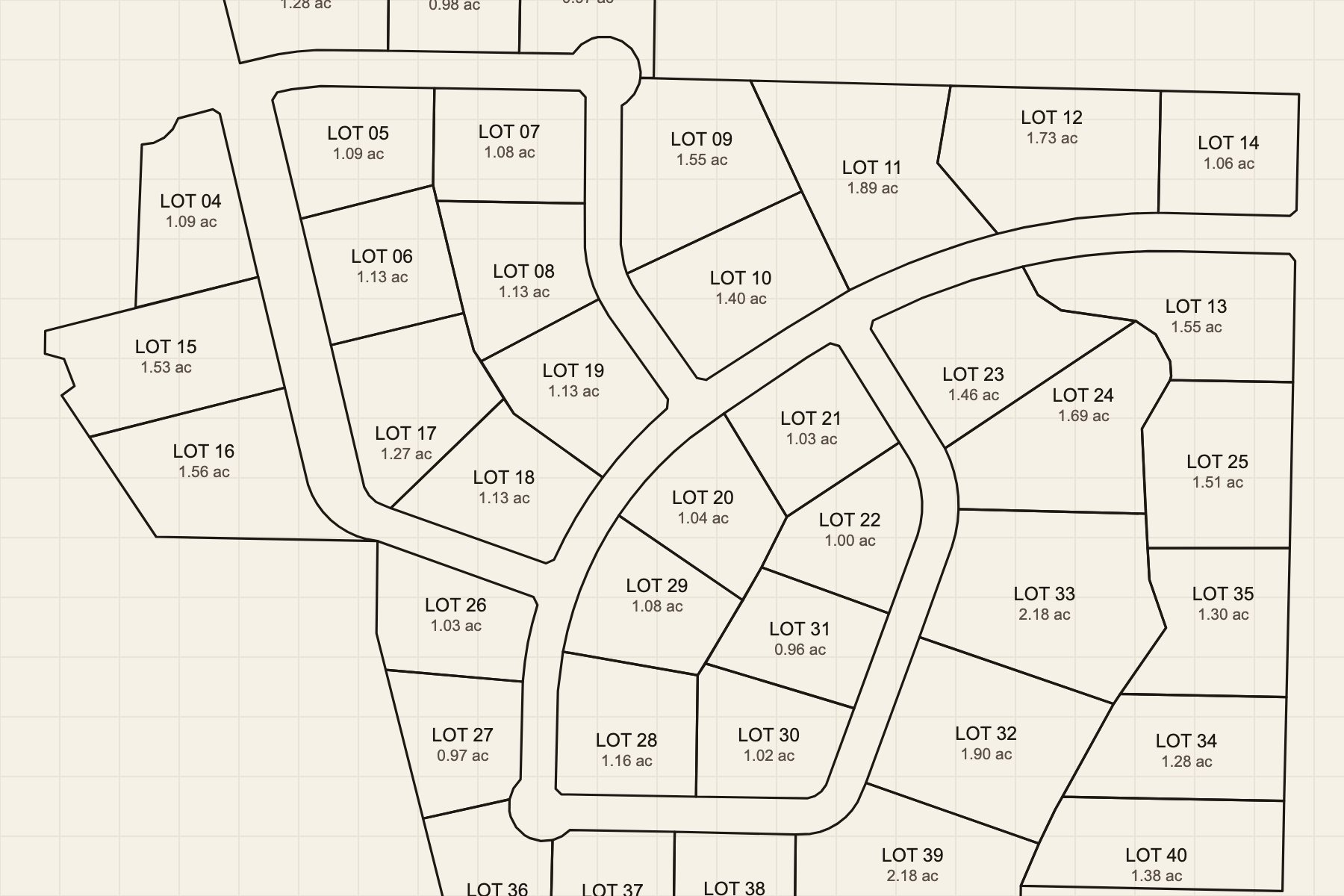
Plat map with lot lines, numbers and acreage
What the buyer gets today. Lines, numbers and acreage. They can't tell where it is, how to get there or what the ground is like.
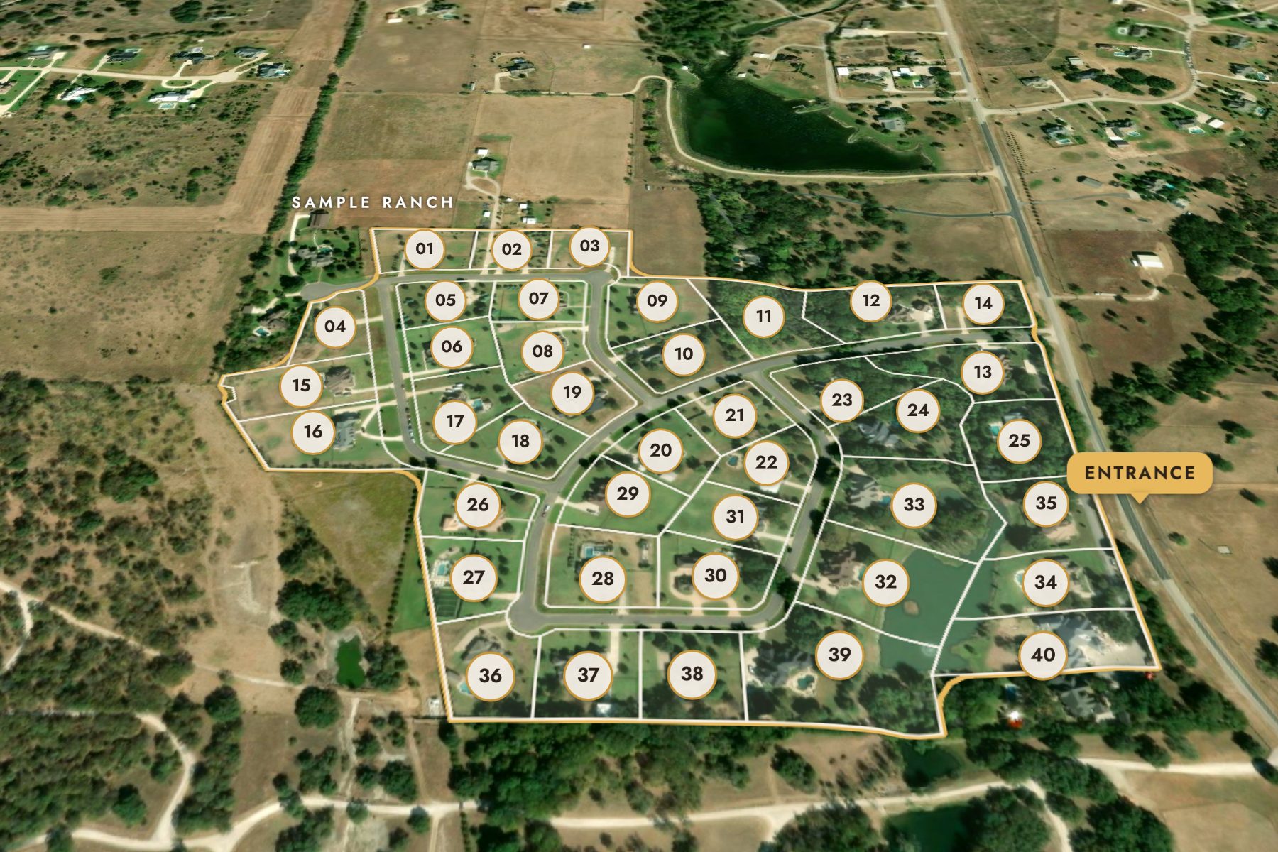
The same subdivision on the 3D map, on satellite imagery and terrain
The same subdivision on the 3D map. On the real land, with the terrain and the area around it. They understand it in ten seconds.

Where is it

Your property on satellite imagery, with the towns, creeks and landmarks around it.

How far is everything

Real driving routes from the entrance to town, the hospital, the school and the airport, with miles and drive time.

What is the ground like

3D terrain, contour lines, elevation, slope and which way each lot faces.

What's in your map

Built from your land, not from a template.

Every map is assembled from your parcels or plat and the place where they sit. You pick the routes and the landmarks that matter to someone buying out there.

Every lot, with its numbers

Tap a lot: acreage and square feet, side lengths, elevation, slope and sun exposure. Filter by road frontage, creek, wooded or over 5 acres.

Real routes to town

From your entrance to where buyers go every day, with miles and drive time. You choose the destinations.

Landmarks nearby

Schools, hospitals, trailheads, rivers and lakes, pinned with distance and a one-tap directions link.

3D terrain and satellite

The real shape of the land, with contour lines, town names and creeks you can switch on and off.

Presentation mode

At an open house or on a TV, the camera tours every lot and route by itself. Nobody has to touch it.

Your brand

Your logo, colors and a cover photo. Works on phones and tablets, and keeps working with spotty cell service.

Search and filters

Buyers type a lot number or a name and find it instantly. In the list they filter by what matters: creek, wooded, road frontage, bigger lots.

A link straight to the lot

A share button on every lot: your agent sends a link that opens the map already on that lot, with acreage and terrain on screen.

Several towns, one map

Working in more than one town or county? A selector takes the buyer from one to the next, each with its own developments.

Hardly anyone has one

Most land listings show a plat and a few photos. Yours will show the place.

Land is sold with signs, flyers and a drone clip. Very few subdivisions have an interactive 3D map of their own property. A buyer who opens your link hasn't seen that anywhere else, and it counts when they compare.

Plat and flyerBuyers can't judge scale, slope or access from them.
Drone clipShows it once, the way it was filmed. It can't answer the question the buyer has.
Listing-site pinA dot on a road map. No lot lines, no terrain, no drive times.
Interactive 3D mapThe buyer explores as long as they like, on their own phone, and shows up to the visit already sold on the place.
The math

On a 12-lot subdivision, the map costs about 0.1% of sales.

12 lots at $85,000$1.02Min sales
Commission on a single lot$5,100at 6%
Interactive 3D map$9970.1% of sales · one-time · 30 days of Live Map included

If the map helps one lot sell a week sooner, or one buyer decide without a second trip, it has paid for itself. After that it keeps working on every inquiry, every showing and every listing page.

Open house tabletText and email to buyersYour websiteZillow, LandWatch and Land.com listingsFacebook and Instagram adsLink in bio
How it works

You see it finished before you pay.

You send your parcels

A KMZ, KML, shapefile or GeoJSON of the lots, or the plat as a PDF. Use the form below. Large files are fine.

Preview in 48 hours

We email you your subdivision on the map, with a watermark. The link stays live for 7 days.

Approve it, it's yours

Pay once by card and get the final version with no watermark, your own link, and the embed code for your site. It never expires.

Live Map · owner dashboard

See which lots buyers open the most.

Along with the map you get a private dashboard. It shows what happens to your link while your agents and ads send people to it.

Most-viewed lots

A heat map on top of your subdivision: which lots buyers open, and how often.

"I want this lot"

The buyer taps a button and lands in your phone's text or email with the lot number filled in. The dashboard counts every tap.

Agent leaderboard

Each agent shares the link with their own name on it. You see who brought the most people and the most interest.

Where they come from

Opens per day, city, text, Facebook or Instagram, phone or computer, time on the map and routes checked.

Availability, live

Sold or under contract? Text us "lot 14 sold" and the lot changes color on the map the same day.

No personal data

Anonymous counts only. No names, phone numbers or tracking cookies from the people who open your map.

Add areas and lots yourself

Launched a new development? Upload the KMZ, KML or CAD file right in the dashboard and it goes on the map in a few minutes. Nobody to wait for.

Name and status, instantly

Rename a development or mark it new launch, under construction, completed or sold out. Buyers see the change right away.

One link per channel

Ready-made links for email, Facebook, Instagram, your website, open houses and ads, plus a link with each agent's name. The dashboard shows where every visit came from.

The map is yours and stays online with no end date. You pay once and it never expires.

What is monthly is only Live Map: keeping sold and under-contract lots up to date, the dashboard measurements and the adjustments you ask for. The first 30 days of Live Map are included. After that, keeping lot availability updated and the full dashboard is $97/month, optional. If you skip it, your map stays online exactly as it was, frozen at its last update. It does not expire.

Pricing
$997 one-time
Pay by card, only after you approve the preview. The map is yours for good and does not expire.
Includes 30 days of Live Map. After that, $97/month only if you want updates and the full dashboard.
  • Complete interactive 3D map of your subdivision
  • Routes and landmarks you choose
  • 3D terrain, contour lines, town names and creeks
  • Presentation mode for open houses and TVs
  • Your brand and your own link, live with no expiration
  • "I want this lot" button to your phone or email
  • Search, share-a-lot links and a town selector
  • 30 days of Live Map: sold and reserved lots updated, plus the visits dashboard, with uploads of new areas and lots by you
Get my free preview

Less than the commission on one lot.

One lot sold sooner pays for the map. The rest is shorter conversations, better-prepared showings and a property that looks bigger than the next listing.

And you only pay after you've seen yours finished.

Questions
Do I pay before I see it?

No. You get the preview of your subdivision within 48 hours and pay only if you approve. The preview has a watermark and stays live for 7 days.

Does the map expire?

No. Once you approve and pay, the map is yours and stays online with no end date. The optional Live Map plan only covers updating lot availability and the full dashboard. If you stop it, the map keeps working, frozen at its last update.

What do you need from me?

Ideally a KMZ, KML, shapefile or GeoJSON with your lot lines. A recorded plat as a PDF or a CAD file also works: with the plat and the address we place the subdivision on the map. If your county publishes parcel data, tell us the county and parcel numbers and we can start from that.

How accurate are the lot lines?

They are as accurate as the file you give us, and the map is a marketing tool, not a survey. Acreage and side lengths come from your lot lines. Elevation and slope come from public ~30 m elevation data and are approximate. Buyers should rely on the recorded plat and a survey for legal boundaries.

How long does it take?

The preview arrives within 48 hours after your files do. Once you approve, the final version is ready within 2 business days.

How do I mark lots sold or reserved?

Text or email us ("lot 14 sold", "lot 7 reserved") and the lot changes color on the map the same day. That is part of Live Map: 30 days included, then $97/month if you want to continue.

What if I don't want the monthly plan?

The map stays online exactly as it was on the last day, with the "I want this lot" button still working. Only the lot updates and the dashboard details stop. You can come back whenever you like.

Can I add new lots or areas later?

Yes, by yourself. In the Live Map dashboard you upload the KMZ, KML, GeoJSON, DXF, DWG or SHP (zip) for a new development, for the lots of a development, or for an area of interest. If the file checks out it goes on the map in a few minutes; if something looks off, we review it before publishing.

Can a buyer send one specific lot to someone?

Yes. Every lot has a share button: the link opens the map already on that lot. If the link carries an agent's name, the dashboard credits the visit to that agent.

I have land in more than one town. Does it fit one map?

Yes. The map gets a town selector: the buyer picks a town and sees its developments. A town with no development yet shows as "coming soon".

What does the dashboard show?

Opens per day, unique visitors, a heat map of the lots, taps on "I want this lot", an agent leaderboard, cities, source (text, Facebook, Instagram, your site), device, time on the map and the routes checked.

What about privacy?

The dashboard uses anonymous counts only. It does not store names, phone numbers, email addresses or advertising cookies from the people who open your map. Your own contact details appear only on the button you choose.

Does it work at an open house with no signal?

Yes. Opened once on a tablet, the map saves itself and keeps working offline. It can also be added to the home screen like an app.

Can I put it on my website or my listings?

Yes. You get your own link and the embed code for your site. The link also works in your Zillow, LandWatch or Land.com listing description, in emails and in ads.
Free preview

Send us your land.

Fill this in, attach your parcels or plat and send it. Within 48 hours you get a preview of your subdivision finished, with a watermark.

$997one-time, only if you approve the preview · includes 30 days of Live Map, then $97/month optional
KMZ, KML, shapefile (zip), GeoJSON, PDF, image or DWG, up to 2 GB per file.

Received.